
OSINT Issues: Pesky Clouds are Blocking my Satellite View!
Are you into Open Source Intelligence (OSINT)?
Have you ever found yourself eager to obtain satellite imagery of a specific area, only to hit a wall of clouds?
As an OSINT analyst with extensive experience in open-source geospatial intelligence (GEOINT) resources, I’ve encountered this situation more times than I can count.
Having worked on projects related to both the Middle East and Russia, I can attest that pesky clouds rarely interfere with satellite views of Syria, Iraq, or Yemen.
The views in these regions are typically unobstructed, crisp, and naturally contrasting, thanks to the desert landscape.
However, when dealing with Russian sites, especially during winter, obtaining a clear picture without clouds is a rare occurrence.
Sometimes, clouds persist for days, if not weeks.
This challenge extends to monitoring maritime environments, such as Houthi attacks on international shipping, where cloud cover can significantly hinder research efforts.
Leaving anecdotal evidence aside, the reality is that only 30% of Earth is free of clouds at any given time.
While there’s no perfect solution to bypass Mother Nature, viable options do exist.
Ideal Solution: Synthetic Aperture Radar (SAR)
Synthetic Aperture Radar, or SAR, was essentially developed to address the challenge of capturing images of locations on Earth irrespective of weather conditions or time of day.
SAR satellites are equipped with a radar system that illuminates the Earth and measures the reflected signal, allowing photography independent of solar light.
Although the end result resembles a radiography more than a typical picture, SAR will show you what’s under the hood.
For freely available resources, ESA’s Sentinel-1 satellite is a good option, accessible via EO Browser or Copernicus Browser.
However, be aware that the resolution is relatively low, and interpreting imagery can be challenging, although it performs better in maritime applications.

Russian naval drills in occupied-Crimea (T-Intelligence analysis based on Sentinel-1 SAR imagery)
But if you or your company have a budget, you can opt for high-resolution or ultra-high-resolution SAR images.
There’s a growing market of SAR providers that can service those requirements– examples are companies like Umbra, Capella, and ICEYE.
SAR is actually a growing industry within the geospatial intelligence market and an increasingly ubiquitous resource.
The radiography-like monochrome pictures are now even present in press articles and investigations.
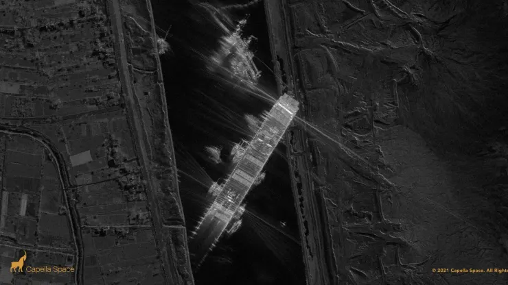
Capella Space image of EVER GIVEN featured on CNBC (copyright Capella Space)

Umbra SAR imagery of the crash site of the plane believed to have been carrying Prigozhin, featured in CNN (copyright Umbra/Joel Morrison)
Better Than Nothing: Sentinel-2 Bandings
An alternative is to use ESA’s Sentinel-2 and experiment with bandings in the EO Browser.
If cloud cover is limited, utilizing False Color and other bandings can highlight specific ground areas.
While not ideal, it’s better than having no solution.
No Alternative: Wait It Out
The last alternative is just to wait the clouds out.
Set reminders to check back when your satellite imagery catalog refreshes.
Some browsers offer notifications when a new image with parameters like <30% cloud coverage appears.
Regardless of the option chosen, it’s crucial to remember that dealing with cloud interference is a regular and unpleasant occurrence.
This awareness becomes especially important when working on tight deadlines or for clients.
While frustrations may arise when facing those pesky clouds, it’s essential to appreciate the capabilities we now have and that weren’t available just a few years back.
by Vlad Sutea
Knowmad OSINT instructor
